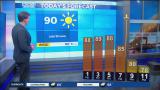
Earlier today, high temperatures across New Orleans reached 81 degrees, but another cold front will roll through again tonight to lower humidity!
Fog was an issue this morning, nonetheless, few storms will accompany the boundary.
Overnight, over Northshore locations, temperatures remain steady as residents wake up with 50s-60s outside while Southshore residents wake up with 60s.
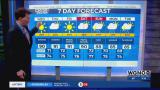
Dry air will be behind this air mass, sticking around for foreseeable days ahead! Climate Prediction Center outlooks show conditions stay average during your upcoming weekend! Conditions will be below average next week! We have one more front arriving late Sunday, and this is when it feels like Fall once more!
Our highs forecasts for next week remain in the 70s each and everyday!
Remember, Hurricane Season 2020 does not end until November 30th. We are closely watching one disturbance for formation potential near the Caribbean Sea.
Right now, this is no immanent concern here locally but worth keeping an eye on based off of its high development potential! Iota is next on the Greek Alphabet list!
Enjoy an incredibly welcome forecast for minimal rain plus quiet, seasonal conditions!
Check out current conditions near you: https://digital-release.wgno.com/weather/new-orleans-weather-radar/
Stay up to date with the latest forecast: digital-release.wgno.com/weather/forecast/
Download the WGNO Weather App to stay connected this hurricane season