—
9:00 PM
As expected the National Hurricane Center has moved the track of Eta farther east and more in line with many of the major models. The storm is stronger at 65 mph and could still become a hurricane briefly before weakening as it approaches the coast.
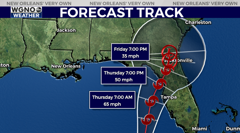
This storm will bring storm surge and high rainfall totals to Florida.
—
6:30 PM
The latest track from the National Hurricane Center for Eta keeps the forecast east of our area with southeast Louisiana not in the cone at the moment.
There are still a few of the models that bring the storm further to the west but the majority are more clustered in the eastern Gulf, and actually some of the main ones move it into Florida even farther south than the current projection.
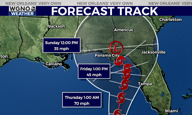
The storm will also likely weaken quite a bit as it moves into the northern Gulf. This is still worth watching of course over the next few days.
Otherwise we have a front coming into the area Wednesday night and Thursday. This will help to keep Eta east of the area. There will not be significantly cooler air behind it but there will be lower humidity which will mean nicer morning temperatures.
Expect another warm and muggy day Wednesday with highs topping out in the low 80s. We could see a couple of spotty showers but nothing too widespread.
Look for much nicer weather by the end of the week. Right now it looks like a stronger front with much cooler air moves in early next week.
Check out current conditions near you: https://digital-release.wgno.com/weather/new-orleans-weather-radar/
Stay up to date with the latest forecast: digital-release.wgno.com/weather/forecast/
Download the WGNO Weather App to stay connected this hurricane season